
Reference Manual


Table Of Contents
- Table of Contents
- Welcome
- Main Menu
- File Menu
- Job Menu
- Job Menu – GPS
- Job Menu – Basic GPS
- Survey Menu
- Backsight Setup
- Traverse / Sideshot
- Repetition Shots
- Multiple Sideshots
- Radial Sideshots
- Distance Offset Shot
- Horizontal Angle Offset
- Vertical Angle Offset
- Auto Collect
- Corner & 2 Lines
- Corner & Angle
- Corner & Offset
- Corner & Plane
- Surface Scan
- Video Scan
- Shoot From Two Ends
- Record Mode
- Resection
- Remote Elevation
- Check Point
- Solar Observation
- Remote Control
- Survey Menu – GPS
- Survey Menu – Basic GPS
- Leveling Menu
- Stakeout Menu
- Stakeout Menu – GPS and Basic GPS
- Inverse Menu
- Cogo Menu
- Curve Menu
- Roads Menu
- Adjust Menu
- Miscelaneous Screens
- Appendix A
- Index
Inverse Menu
R-359
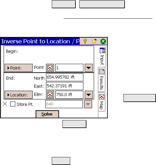
Inverse Point to Location /
Point
Inverse Location / Point.
The Inverse Point to Location / Point screen will calculate the
distance and direction from any point or location to another point or
location.
Begin: is the reference point or location used to
compute the distance and direction to another
point or location.
End: is the other point or location whose
correlation to the Begin point or location is
computed. Each location is defined by one of
the following methods:
• Location: : when selected, the coordinates
for any location can be entered in the
appropriate fields.
• Point: : when selected, any existing point name can be entered
in the appropriate field or selected from a map view.
; Store Pt.: When checked, will store a point for the location(s)
entered.
Solve : will compute the distance and direction from the Begin point
or location to the End point or location.