
Reference Manual


Table Of Contents
- Table of Contents
- Welcome
- Main Menu
- File Menu
- Job Menu
- Job Menu – GPS
- Job Menu – Basic GPS
- Survey Menu
- Backsight Setup
- Traverse / Sideshot
- Repetition Shots
- Multiple Sideshots
- Radial Sideshots
- Distance Offset Shot
- Horizontal Angle Offset
- Vertical Angle Offset
- Auto Collect
- Corner & 2 Lines
- Corner & Angle
- Corner & Offset
- Corner & Plane
- Surface Scan
- Video Scan
- Shoot From Two Ends
- Record Mode
- Resection
- Remote Elevation
- Check Point
- Solar Observation
- Remote Control
- Survey Menu – GPS
- Survey Menu – Basic GPS
- Leveling Menu
- Stakeout Menu
- Stakeout Menu – GPS and Basic GPS
- Inverse Menu
- Cogo Menu
- Curve Menu
- Roads Menu
- Adjust Menu
- Miscelaneous Screens
- Appendix A
- Index
Survey Pro Reference Manual
R-358
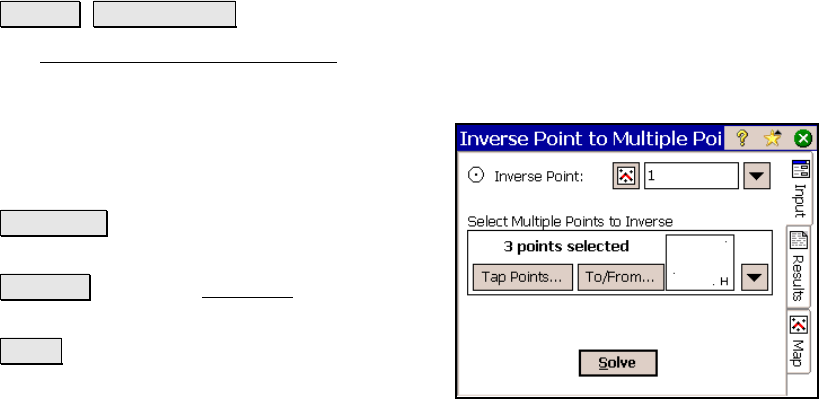
Inverse Point to Multiple
Points
Inverse Multiple Points.
The Inverse Point to Multiple Points screen will calculate the
distance and direction from an existing point to one or more other
points.
Inverse point: is the reference point used to
compute the distance and direction to the other
points.
Tap Points : provides a map view where you
can tap multiple points.
To/From : Opens the Point List screen (Page
R-449) where a point list can be created.
Solve : will compute the distance and direction
from the Inverse point to all selected points.
Results
Azimuth: is the azimuth from the Inverse Point to the selected point.
Horz Dist: is the horizontal distance from the Inverse Point to the
selected point.
Vert Dist: is the vertical distance from the Inverse Point to the
selected point.
Slope Dist: is the slope distance from the Inverse Point to the selected
point.
North: is the change in the Y-coordinate from the Inverse Point to the
selected point.
East: is the change in the X-coordinate from the Inverse Point to the
selected point.