
Reference Manual


Table Of Contents
- Table of Contents
- Welcome
- Main Menu
- File Menu
- Job Menu
- Job Menu – GPS
- Job Menu – Basic GPS
- Survey Menu
- Backsight Setup
- Traverse / Sideshot
- Repetition Shots
- Multiple Sideshots
- Radial Sideshots
- Distance Offset Shot
- Horizontal Angle Offset
- Vertical Angle Offset
- Auto Collect
- Corner & 2 Lines
- Corner & Angle
- Corner & Offset
- Corner & Plane
- Surface Scan
- Video Scan
- Shoot From Two Ends
- Record Mode
- Resection
- Remote Elevation
- Check Point
- Solar Observation
- Remote Control
- Survey Menu – GPS
- Survey Menu – Basic GPS
- Leveling Menu
- Stakeout Menu
- Stakeout Menu – GPS and Basic GPS
- Inverse Menu
- Cogo Menu
- Curve Menu
- Roads Menu
- Adjust Menu
- Miscelaneous Screens
- Appendix A
- Index
Survey Pro Reference Manual
R-356
North: is the Y-coordinate on the specified line, tangent to the
perpendicular offset.
East: is the X-coordinate on the specified line, tangent to the
perpendicular offset.
Elevation: is the elevation on the specified line, tangent to the
perpendicular offset.
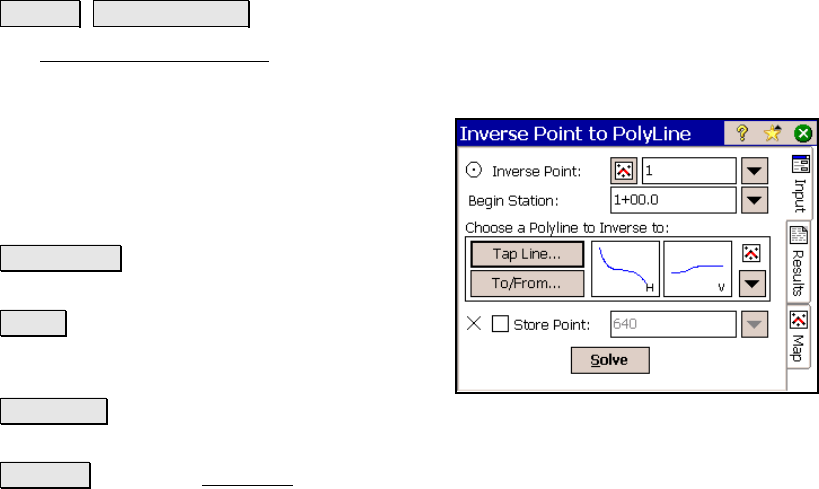
Inverse Point to Polyline
Inverse Point to Polyline.
The Inverse Point to Polyline screen computes the offset distance
from a known point perpendicular to a polyline.
Inverse Point: is the known point that the
offset to a polyline segment is computed.
Begin Station: is the starting station assigned
to the beginning of the polyline, which is used
to compute the Station in the results.
Tap Polyline : allows you to tap an existing
polyline from a map view.
Editor : opens the Polyline Editor (Page R-67)
where a new polyline can be created or an
existing polyline can be modified.
Tap Points : provides a map view where you can tap any existing
points to create a temporary polyline.
To/From : Opens the Point List screen (Page R-449) where a point
list can be created.
; Store Point: When checked, will store the first solution where a
perpendicular offset intersects with a polyline using the specified
point name. If additional solutions are found, the following solutions
will be stored using consecutive point names.