
Reference Manual


Table Of Contents
- Table of Contents
- Welcome
- Main Menu
- File Menu
- Job Menu
- Job Menu – GPS
- Job Menu – Basic GPS
- Survey Menu
- Backsight Setup
- Traverse / Sideshot
- Repetition Shots
- Multiple Sideshots
- Radial Sideshots
- Distance Offset Shot
- Horizontal Angle Offset
- Vertical Angle Offset
- Auto Collect
- Corner & 2 Lines
- Corner & Angle
- Corner & Offset
- Corner & Plane
- Surface Scan
- Video Scan
- Shoot From Two Ends
- Record Mode
- Resection
- Remote Elevation
- Check Point
- Solar Observation
- Remote Control
- Survey Menu – GPS
- Survey Menu – Basic GPS
- Leveling Menu
- Stakeout Menu
- Stakeout Menu – GPS and Basic GPS
- Inverse Menu
- Cogo Menu
- Curve Menu
- Roads Menu
- Adjust Menu
- Miscelaneous Screens
- Appendix A
- Index
Survey Pro Reference Manual
R-354
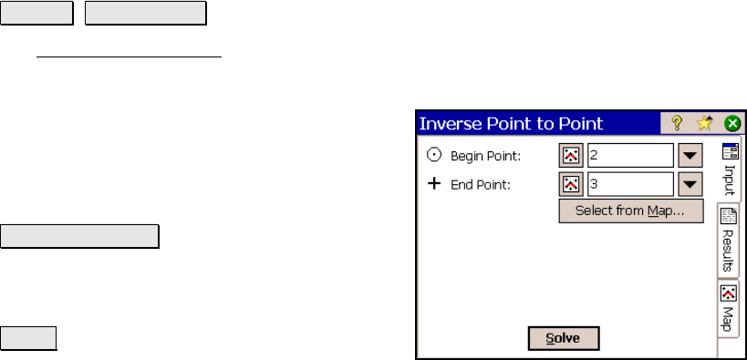
Inverse Point to Point
Inverse Point to Point.
The Inverse Point to Point screen will calculate the distance and
direction between two existing points.
Begin Point: is the reference point used to
compute the distance and direction to the End
Point.
End Point: is the point whose relationship to
the Begin Point is computed.
Select from Map… : allows you to quickly select
both the Begin Point and End Point from a map
view. The first point tapped is entered as the
Begin Point and the second as the End Point.
Solve : will compute the distance and direction
from the Begin Point to the End Point.
Results
Azimuth: is the azimuth from the Begin Point to the End Point.
Horz Dist: The horizontal distance from the Begin Point to the End
Point.
Vert Dist: The vertical distance from the Begin Point to the End Point.
Slope Dist: is the slope distance from the Begin Point to the End Point.
North: The change in the Y-coordinate from the Begin Point to the
End Point.
East: The change in the X-coordinate from the Begin Point to the End
Point.
Elevation: The change in elevation from the Begin Point to the End
Point.
Grade: is the slope from the Begin Point to the End Point.