
Reference Manual


Table Of Contents
- Table of Contents
- Welcome
- Main Menu
- File Menu
- Job Menu
- Job Menu – GPS
- Job Menu – Basic GPS
- Survey Menu
- Backsight Setup
- Traverse / Sideshot
- Repetition Shots
- Multiple Sideshots
- Radial Sideshots
- Distance Offset Shot
- Horizontal Angle Offset
- Vertical Angle Offset
- Auto Collect
- Corner & 2 Lines
- Corner & Angle
- Corner & Offset
- Corner & Plane
- Surface Scan
- Video Scan
- Shoot From Two Ends
- Record Mode
- Resection
- Remote Elevation
- Check Point
- Solar Observation
- Remote Control
- Survey Menu – GPS
- Survey Menu – Basic GPS
- Leveling Menu
- Stakeout Menu
- Stakeout Menu – GPS and Basic GPS
- Inverse Menu
- Cogo Menu
- Curve Menu
- Roads Menu
- Adjust Menu
- Miscelaneous Screens
- Appendix A
- Index
Stakeout Menu
R-329
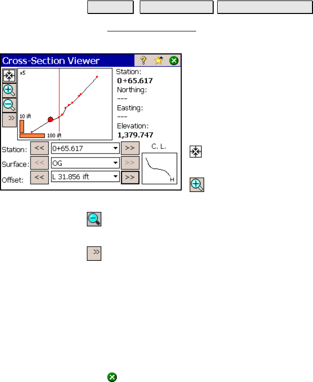
Cross-Section View
Stakeout Station Staking View Cross-Sections.
The Cross-Section View screen is used to view the station, surface,
and offset details of the loaded LandXML file.
The upper portion of the screen lists the
Station, Northing, Easting, and Elevation at the
selected node.
The larger graphic area displays the cross-
sectional view of the selected surface. The
smaller graphic area displays the horizontal
view of the centerline.
Zoom Extents: will zoom so the entire cross
section will fit inside the frame.
Zoom In Button: will zoom the current
screen in by approximately 25%.
Zoom Out Button: will zoom the current screen out by
approximately 25%.
: expands a list where you can select to zoom to a window, zoom up
vertically, or zoom down vertically.
Stations: allows you to scroll through and view all the stations in the
LandXML file.
Surfaces: allows you to scroll through and view all the surfaces in the
LandXML file.
Offset: allows you to scroll through and view the details of the node
at the selected offset.
Tap
to exit from this screen.