
Reference Manual


Table Of Contents
- Table of Contents
- Welcome
- Main Menu
- File Menu
- Job Menu
- Job Menu – GPS
- Job Menu – Basic GPS
- Survey Menu
- Backsight Setup
- Traverse / Sideshot
- Repetition Shots
- Multiple Sideshots
- Radial Sideshots
- Distance Offset Shot
- Horizontal Angle Offset
- Vertical Angle Offset
- Auto Collect
- Corner & 2 Lines
- Corner & Angle
- Corner & Offset
- Corner & Plane
- Surface Scan
- Video Scan
- Shoot From Two Ends
- Record Mode
- Resection
- Remote Elevation
- Check Point
- Solar Observation
- Remote Control
- Survey Menu – GPS
- Survey Menu – Basic GPS
- Leveling Menu
- Stakeout Menu
- Stakeout Menu – GPS and Basic GPS
- Inverse Menu
- Cogo Menu
- Curve Menu
- Roads Menu
- Adjust Menu
- Miscelaneous Screens
- Appendix A
- Index
Stakeout Menu
R-321
Note: A negative slope will result in water running from the
centerline toward the edge of payment.
; Stake Curb / Ditch: When checked, a curb or ditch and an offset
can be defined beyond the edge of the pavement.
Height: is the height of the curb or ditch in feet or meters. A positive
value is considered a curb and a negative value a ditch.
Offset From Edge of Road: is the distance that the curb or ditch
extends from the edge of pavement.
Note: The specified curb or ditch height and offset will be applied to
both sides of the road.
< Back : returns to the previous screen.
Next > : opens the next screen.
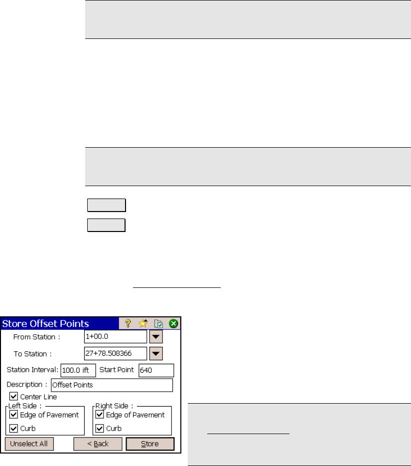
Store Offset Points – Screen Three
The third Store Offset Points screen is used to define which offset
points will be stored.
From Station: is the station where the stored
offset points will begin.
To Station: is the station where the stored
offset points will end.
Station Interval: is the distance between the
stations where offset points are stored.
Note: If the Stake Corners option is selected in
the Stakeout Settings screen, offset points will
also be stored where ever the horizontal or
vertical section of the road changes.