
Reference Manual


Table Of Contents
- Table of Contents
- Welcome
- Main Menu
- File Menu
- Job Menu
- Job Menu – GPS
- Job Menu – Basic GPS
- Survey Menu
- Backsight Setup
- Traverse / Sideshot
- Repetition Shots
- Multiple Sideshots
- Radial Sideshots
- Distance Offset Shot
- Horizontal Angle Offset
- Vertical Angle Offset
- Auto Collect
- Corner & 2 Lines
- Corner & Angle
- Corner & Offset
- Corner & Plane
- Surface Scan
- Video Scan
- Shoot From Two Ends
- Record Mode
- Resection
- Remote Elevation
- Check Point
- Solar Observation
- Remote Control
- Survey Menu – GPS
- Survey Menu – Basic GPS
- Leveling Menu
- Stakeout Menu
- Stakeout Menu – GPS and Basic GPS
- Inverse Menu
- Cogo Menu
- Curve Menu
- Roads Menu
- Adjust Menu
- Miscelaneous Screens
- Appendix A
- Index
Survey Pro Reference Manual
R-320
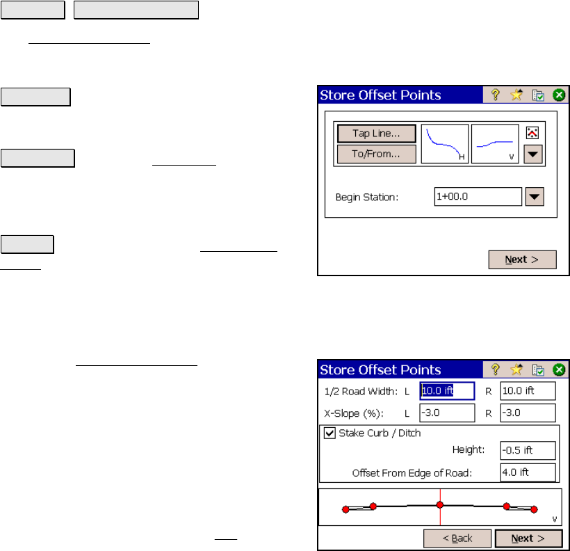
Store Offset Points
Stakeout Store Offset Points.
The Store Offset Points screen is used to store points in the current
job at a specified offset from an existing polyline or alignment at a
specified interval.
Tap Line… : allows you to tap an existing
polyline or alignment that the station and
offset will be computed from.
To/From… : Opens the Point List screen (Page
R-449) where a point list can be created.
Begin Station: is the station assigned to the
beginning of the line.
Next > : takes you to the next Store Offset
Points screen where the slope staking
parameters are set up.
Store Offset Points – Screen Two
The second Store Offset Points screen is used
to define the road profile, or offset distances
that will be used to compute the offset point
coordinates.
1/2 Road Width: is the Left and Right width
of the road, respectively, from the centerline to
the edge of payment.
X-Slope (%): is the Left and Right slope of the
road, respectively, from the centerline to the
edge of payment calculated from
100
Run
Rise
⋅ .