
Reference Manual


Table Of Contents
- Table of Contents
- Welcome
- Main Menu
- File Menu
- Job Menu
- Job Menu – GPS
- Job Menu – Basic GPS
- Survey Menu
- Backsight Setup
- Traverse / Sideshot
- Repetition Shots
- Multiple Sideshots
- Radial Sideshots
- Distance Offset Shot
- Horizontal Angle Offset
- Vertical Angle Offset
- Auto Collect
- Corner & 2 Lines
- Corner & Angle
- Corner & Offset
- Corner & Plane
- Surface Scan
- Video Scan
- Shoot From Two Ends
- Record Mode
- Resection
- Remote Elevation
- Check Point
- Solar Observation
- Remote Control
- Survey Menu – GPS
- Survey Menu – Basic GPS
- Leveling Menu
- Stakeout Menu
- Stakeout Menu – GPS and Basic GPS
- Inverse Menu
- Cogo Menu
- Curve Menu
- Roads Menu
- Adjust Menu
- Miscelaneous Screens
- Appendix A
- Index
Survey Pro Reference Manual
R-268
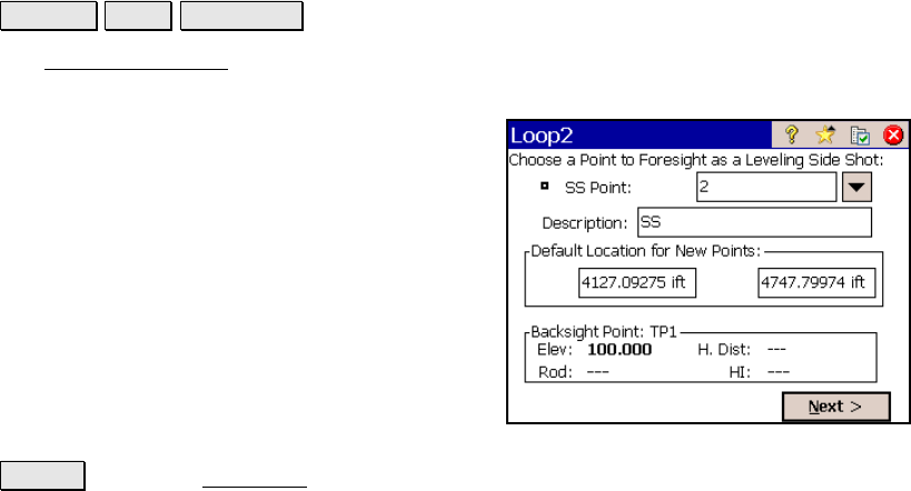
Leveling Side Shot
Leveling Level Sideshot >.
The Leveling Sideshot screen is used to describe a leveling side shot
before taking the necessary shots to record it.
SS Point: is the name for the new point.
Desc: is an optional description for the new
point.
Default Location for New Points: is where
you specify the northing and easting to use
when the new point is stored since the leveling
procedure cannot compute these.
Backsight Point: Lists the details for the
current backsight. If this is the first
observation from the current set up, most of
the details will be unknown.
Next > : opens the Take Shot screen (Page R-266) where the
required shots are performed.