
Reference Manual


Table Of Contents
- Table of Contents
- Welcome
- Main Menu
- File Menu
- Job Menu
- Job Menu – GPS
- Job Menu – Basic GPS
- Survey Menu
- Backsight Setup
- Traverse / Sideshot
- Repetition Shots
- Multiple Sideshots
- Radial Sideshots
- Distance Offset Shot
- Horizontal Angle Offset
- Vertical Angle Offset
- Auto Collect
- Corner & 2 Lines
- Corner & Angle
- Corner & Offset
- Corner & Plane
- Surface Scan
- Video Scan
- Shoot From Two Ends
- Record Mode
- Resection
- Remote Elevation
- Check Point
- Solar Observation
- Remote Control
- Survey Menu – GPS
- Survey Menu – Basic GPS
- Leveling Menu
- Stakeout Menu
- Stakeout Menu – GPS and Basic GPS
- Inverse Menu
- Cogo Menu
- Curve Menu
- Roads Menu
- Adjust Menu
- Miscelaneous Screens
- Appendix A
- Index
Survey Pro Reference Manual
R-18
Import *.TXT Coordinates
When importing a TXT file, you will first be prompted to select the
layer where you want the new data stored. Select a layer and tap
to continue.
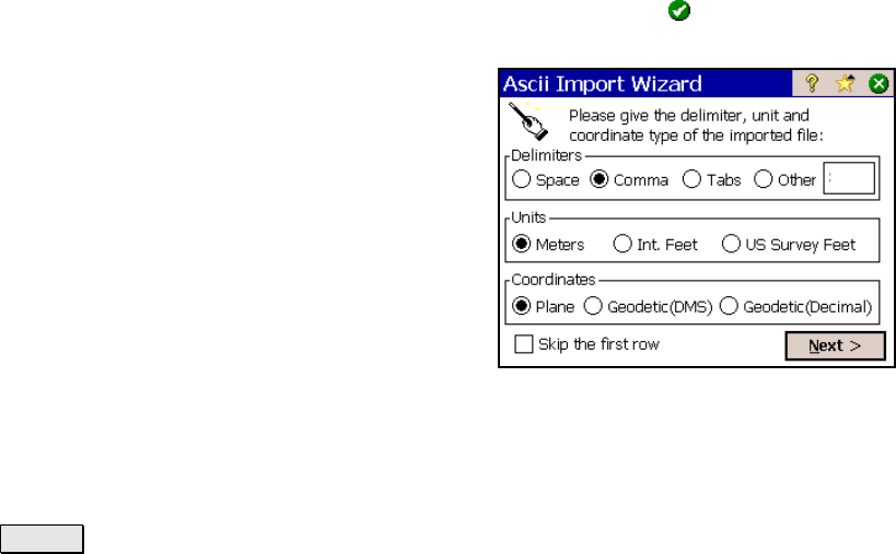
Since the coordinates in an ASCII TXT file can
be stored in a variety of formats, two screens
are used to define the format of the file that is
being imported once a layer is selected. The
source TXT file can contain either plane
coordinates or geodetic coordinates.
Delimiters: is the character that separates
each column of text in the ASCII file.
Units: are the units that the distances in the
file were stored in.
Coordinates: is used to specify if the
coordinates are plane coordinates, geodetic coordinates in degrees-
minutes-seconds format, or geodetic coordinates in decimal format.
; Skip the first row: should be checked if the first line in the ASCII
file contains non-coordinate information, such as a heading.
Next > : opens the second screen.