
Reference Manual


Table Of Contents
- Table of Contents
- Welcome
- Main Menu
- File Menu
- Job Menu
- Job Menu – GPS
- Job Menu – Basic GPS
- Survey Menu
- Backsight Setup
- Traverse / Sideshot
- Repetition Shots
- Multiple Sideshots
- Radial Sideshots
- Distance Offset Shot
- Horizontal Angle Offset
- Vertical Angle Offset
- Auto Collect
- Corner & 2 Lines
- Corner & Angle
- Corner & Offset
- Corner & Plane
- Surface Scan
- Video Scan
- Shoot From Two Ends
- Record Mode
- Resection
- Remote Elevation
- Check Point
- Solar Observation
- Remote Control
- Survey Menu – GPS
- Survey Menu – Basic GPS
- Leveling Menu
- Stakeout Menu
- Stakeout Menu – GPS and Basic GPS
- Inverse Menu
- Cogo Menu
- Curve Menu
- Roads Menu
- Adjust Menu
- Miscelaneous Screens
- Appendix A
- Index
Survey Pro Reference Manual
R-242
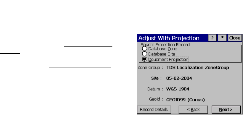
Adjust with Projection – Select Source Coordinate
System
The Adjust with Projection Select Source Coordinate System screen is
used to select the coordinate system of the current job file points.
When the adjustment mode is Readjust with Current Projection, this
screen shows the current coordinate system record details. This
screen only shows when the wizard is opened from the menu.
The Select Source Coordinate System screen is
almost identical to the Select Coordinate
System screen described in the mapping plane
section (Page R-213). The following controls
are sp
ecial to the Adjust with Projection
wizard.
Source Projection Record: is where you select
what type of coordinate system record to
choose for the source. You can:
• Database Zone: will display controls to
pick a map projection from the regions and
zones in the database.
• Database Site: will display controls to pick a localized site record
from either the Site region or the TDS Localization ZoneGroup
group.
• Current Projection: will disable the edit boxes and display the
current projection details. The job file coordinate system record
will be used