
Reference Manual


Table Of Contents
- Table of Contents
- Welcome
- Main Menu
- File Menu
- Job Menu
- Job Menu – GPS
- Job Menu – Basic GPS
- Survey Menu
- Backsight Setup
- Traverse / Sideshot
- Repetition Shots
- Multiple Sideshots
- Radial Sideshots
- Distance Offset Shot
- Horizontal Angle Offset
- Vertical Angle Offset
- Auto Collect
- Corner & 2 Lines
- Corner & Angle
- Corner & Offset
- Corner & Plane
- Surface Scan
- Video Scan
- Shoot From Two Ends
- Record Mode
- Resection
- Remote Elevation
- Check Point
- Solar Observation
- Remote Control
- Survey Menu – GPS
- Survey Menu – Basic GPS
- Leveling Menu
- Stakeout Menu
- Stakeout Menu – GPS and Basic GPS
- Inverse Menu
- Cogo Menu
- Curve Menu
- Roads Menu
- Adjust Menu
- Miscelaneous Screens
- Appendix A
- Index
Survey Menu – GPS Module
R-235
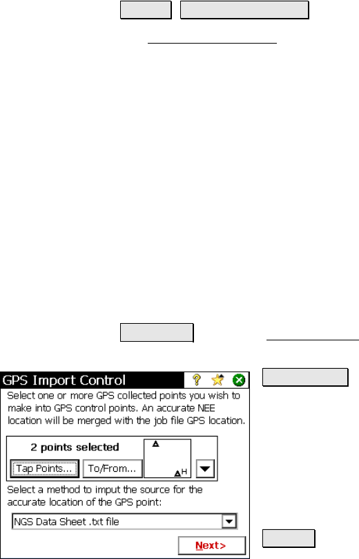
Import GPS Control
Survey Import GPS Control.
The Import GPS Control wizard is used to merge an accurate NEE
location (control point source) with a GPS collected point in the job
file. This point will then be designated as a GPS control point and can
be used to solve a localization adjustment. Solving the localization
adjustment can be done automatically at the end of this wizard,
manually after the end of this wizard, or at a later time. There are
three methods to import the control point source:
• Import from a text format ‘OPUS Solution Report’ email
• Import from a text format ‘NGS Datasheet’ file
• Key in a coordinate in NEE, LLH WGS84, or LLH local
Select Points and Import Source
The first screen is used to select the job points you want to merge
with accurate NEE coordinates to convert to GPS control and select
how you will enter the control point source to get the accurate NEE.
To/From… : opens the Select Point(s) screen where you can select
points by specifying a point range.
Tap Points… : opens a map view where you can
select points by tapping them on the screen.
Select a method…: Is used to select from the
following sources for accurate coordinates.
• OPUS Solution Results .txt file
• NGS Data Sheet .txt file
• Key In Coordinate
Next > : Opens one of two possible screens
depending on the choice made for the Select a
Method… field in the first screen.