
Reference Manual


Table Of Contents
- Table of Contents
- Welcome
- Main Menu
- File Menu
- Job Menu
- Job Menu – GPS
- Job Menu – Basic GPS
- Survey Menu
- Backsight Setup
- Traverse / Sideshot
- Repetition Shots
- Multiple Sideshots
- Radial Sideshots
- Distance Offset Shot
- Horizontal Angle Offset
- Vertical Angle Offset
- Auto Collect
- Corner & 2 Lines
- Corner & Angle
- Corner & Offset
- Corner & Plane
- Surface Scan
- Video Scan
- Shoot From Two Ends
- Record Mode
- Resection
- Remote Elevation
- Check Point
- Solar Observation
- Remote Control
- Survey Menu – GPS
- Survey Menu – Basic GPS
- Leveling Menu
- Stakeout Menu
- Stakeout Menu – GPS and Basic GPS
- Inverse Menu
- Cogo Menu
- Curve Menu
- Roads Menu
- Adjust Menu
- Miscelaneous Screens
- Appendix A
- Index
Survey Menu – GPS Module
R-233
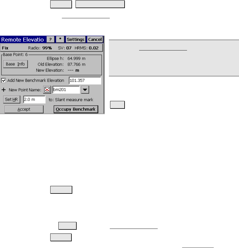
Remote Elevation
Survey Remote Elevation.
The Remote Elevation screen is used to compute and store a new base
point elevation and vertical site by occupying a known vertical
benchmark at the rover.
Note: The Remote Elevation screen is only
available when a geoid model is used for the
vertical projection, the horizontal projection is
already solved and the base and rover are set.
Base Point: displays the current base point
number and elevation details.
Info : opens detailed information about the
base point.
Add Benchmark Elevation: when checked, a new point will be created
in the job file with the entered elevation. We will calculate (N,E) from
the GPS measurement(lat,lng) and store the new point with the
entered Elevation.
Elevation: When Add Benchmark Elevation is checked, this is the
elevation of the new point.
Select Point / New Point: is the existing or new benchmark point
name that you will occupy.
Set HR : displays the current antenna measurement and measure to
setting. You can change the antenna measurement by entering a new
value in the edit box. This new antenna height will be sent to the
receiver with your next data collection point. You can change both
the antenna measurement and measure to setting by tapping
on Set HR to open the Receiver Antenna screen (Page R-188).
Accept : Updates the projection with the vertical solution calculated
from the control point observation and opens the Adjust with