
Reference Manual


Table Of Contents
- Table of Contents
- Welcome
- Main Menu
- File Menu
- Job Menu
- Job Menu – GPS
- Job Menu – Basic GPS
- Survey Menu
- Backsight Setup
- Traverse / Sideshot
- Repetition Shots
- Multiple Sideshots
- Radial Sideshots
- Distance Offset Shot
- Horizontal Angle Offset
- Vertical Angle Offset
- Auto Collect
- Corner & 2 Lines
- Corner & Angle
- Corner & Offset
- Corner & Plane
- Surface Scan
- Video Scan
- Shoot From Two Ends
- Record Mode
- Resection
- Remote Elevation
- Check Point
- Solar Observation
- Remote Control
- Survey Menu – GPS
- Survey Menu – Basic GPS
- Leveling Menu
- Stakeout Menu
- Stakeout Menu – GPS and Basic GPS
- Inverse Menu
- Cogo Menu
- Curve Menu
- Roads Menu
- Adjust Menu
- Miscelaneous Screens
- Appendix A
- Index
Survey Menu – GPS Module
R-223
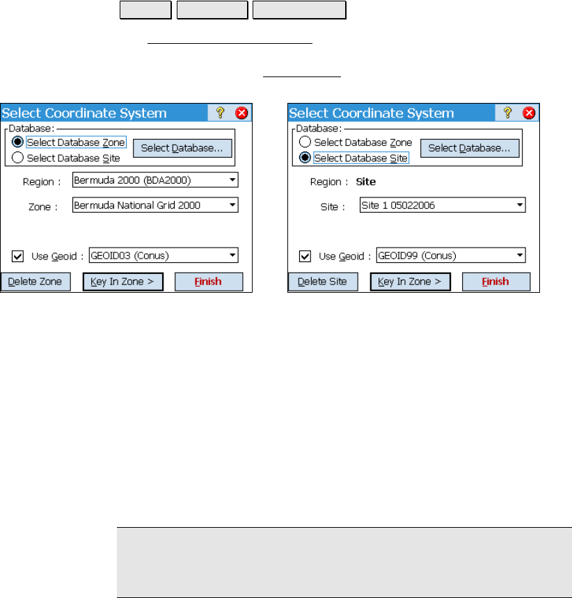
Select Coordinate System
Survey Projection Select Zone….
The Select Coordinate System screen is used to choose a mapping
plane zone or localized site from the coordinate system database file.
You can also open the Key In Zone
wizard to create a new zone and
datum with user specified parameters.
Select Mapping Plane Zone Select Mapping Plane Site
Database: is where you select what type of coordinate system record
to choose. You can:
• Use Database Zone: will display controls to pick a map
projection from the regions and zones in the database.
• Use Database Site: will display controls to pick a localized
zone based site from the Site region in the database.
Region: is where you select the region of the map projection zone.
Zone: is where you select the specific map projection zone.
Datum: is where you view or select the horizontal datum for this zone.
Note: Some zones in the database may not have a default datum
attached. In this case, the datum control is a list box and you must
select from the data base datums before you can set the zone.