
Reference Manual


Table Of Contents
- Table of Contents
- Welcome
- Main Menu
- File Menu
- Job Menu
- Job Menu – GPS
- Job Menu – Basic GPS
- Survey Menu
- Backsight Setup
- Traverse / Sideshot
- Repetition Shots
- Multiple Sideshots
- Radial Sideshots
- Distance Offset Shot
- Horizontal Angle Offset
- Vertical Angle Offset
- Auto Collect
- Corner & 2 Lines
- Corner & Angle
- Corner & Offset
- Corner & Plane
- Surface Scan
- Video Scan
- Shoot From Two Ends
- Record Mode
- Resection
- Remote Elevation
- Check Point
- Solar Observation
- Remote Control
- Survey Menu – GPS
- Survey Menu – Basic GPS
- Leveling Menu
- Stakeout Menu
- Stakeout Menu – GPS and Basic GPS
- Inverse Menu
- Cogo Menu
- Curve Menu
- Roads Menu
- Adjust Menu
- Miscelaneous Screens
- Appendix A
- Index
Survey Pro Reference Manual
R-182
Start GPS Survey
Survey Start GPS Survey.
The Start GPS Survey wizard is used to complete the setup necessary
for any RTK GPS Survey. The Start GPS Survey
wizard is opened
from the main menu, or any time you try to access data collection or
stake out functions. The steps to complete the Start GPS Survey
wizard will depend on what you have already done in the job. Each
possible screen is shown below.
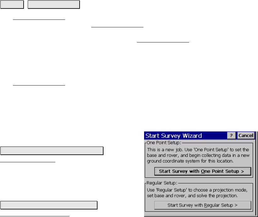
Choose One Point Setup
The Start GPS Survey Choose One Point Setup screen is used to
select one point setup mode. This screen shows when you have a new
job with only one point, and when you have not yet selected a
coordinate system. Use one point setup when you want to start a new
survey at ground level, with no extra steps required to solve the
coordinate system.
One Point Setup: displays a description of one
point setup mode.
Start Survey With One Point Setup>: opens the
Choose Base Setup screen, which will guide
you through starting the survey with the
default ground coordinate system.
Regular Setup: displays a description of
Regular Setup mode.
Start Survey With Regular Setup>: opens the
Choose Projection Mode screen, which is used
to help you solve the coordinate system for this job.