
Reference Manual


Table Of Contents
- Table of Contents
- Welcome
- Main Menu
- File Menu
- Job Menu
- Job Menu – GPS
- Job Menu – Basic GPS
- Survey Menu
- Backsight Setup
- Traverse / Sideshot
- Repetition Shots
- Multiple Sideshots
- Radial Sideshots
- Distance Offset Shot
- Horizontal Angle Offset
- Vertical Angle Offset
- Auto Collect
- Corner & 2 Lines
- Corner & Angle
- Corner & Offset
- Corner & Plane
- Surface Scan
- Video Scan
- Shoot From Two Ends
- Record Mode
- Resection
- Remote Elevation
- Check Point
- Solar Observation
- Remote Control
- Survey Menu – GPS
- Survey Menu – Basic GPS
- Leveling Menu
- Stakeout Menu
- Stakeout Menu – GPS and Basic GPS
- Inverse Menu
- Cogo Menu
- Curve Menu
- Roads Menu
- Adjust Menu
- Miscelaneous Screens
- Appendix A
- Index
Survey Menu – GPS Module
R-181
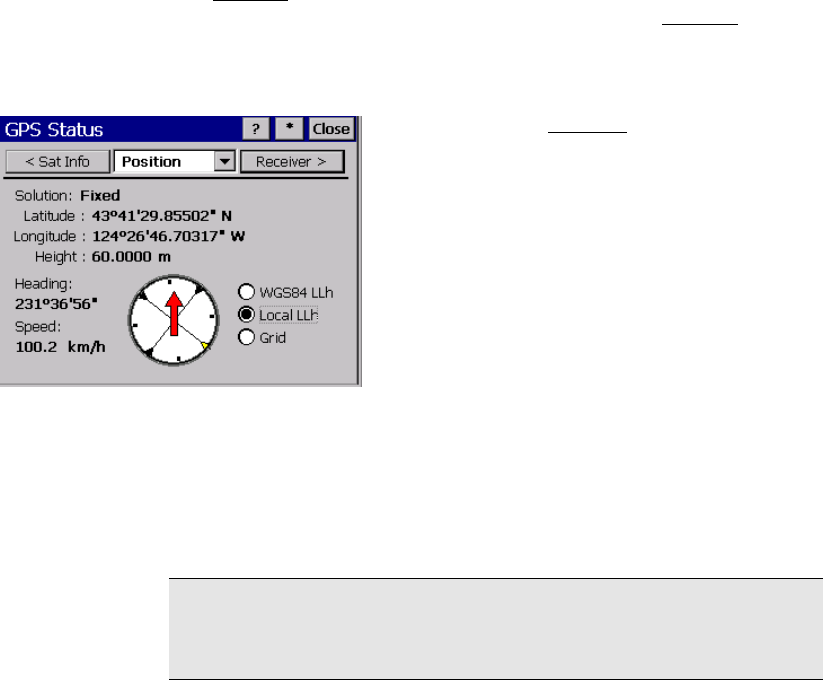
Position
The Position card displays your current position as well as your
course and speed information if you are moving. The Position
card
will display one of three coordinates: WGS84 latitude, longitude,
height; Local latitude, longitude, height; or Grid north, east,
elevation.
Solution: (see the Receiver
card on Page R-
176.)
Latitu
de/Longitude/Height: or North/ East/
Elevation: displays the location of the receiver.
Heading: displays your course over ground if
you are moving. If your coordinate display is
geodetic, this heading is with respect to
geodetic north. If your coordinate display is
grid, then this heading is with respect to grid
north.
Speed: displays your horizontal speed over ground if you are moving.
WGS84: is where you set the position display to show WGS84
latitude, longitude, and height. This option is always available.
Local LLh: is where you set the position display to show Local
latitude, longitude, and height. This option is only available when you
have a coordinate system selected and solved.
Note: Local LLh numbers make sense when in mapping plane mode.
When using Ground – TDS Localization mode, you should not use
Local LLh display.
Grid: is where you set the position display to show Grid north, east,
and elevation. This option is only available when you have a
coordinate system selected and solved.