
Reference Manual


Table Of Contents
- Table of Contents
- Welcome
- Main Menu
- File Menu
- Job Menu
- Job Menu – GPS
- Job Menu – Basic GPS
- Survey Menu
- Backsight Setup
- Traverse / Sideshot
- Repetition Shots
- Multiple Sideshots
- Radial Sideshots
- Distance Offset Shot
- Horizontal Angle Offset
- Vertical Angle Offset
- Auto Collect
- Corner & 2 Lines
- Corner & Angle
- Corner & Offset
- Corner & Plane
- Surface Scan
- Video Scan
- Shoot From Two Ends
- Record Mode
- Resection
- Remote Elevation
- Check Point
- Solar Observation
- Remote Control
- Survey Menu – GPS
- Survey Menu – Basic GPS
- Leveling Menu
- Stakeout Menu
- Stakeout Menu – GPS and Basic GPS
- Inverse Menu
- Cogo Menu
- Curve Menu
- Roads Menu
- Adjust Menu
- Miscelaneous Screens
- Appendix A
- Index
Survey Menu – GPS Module
R-179
• Recording: a file on the receiver or in the data collector is
open and recording GPS raw data. If this receiver monitors
sessions, this field will display: session in progress when a
session is ongoing.
• Not Recording: no file is open and there is no raw data
recording.
Last Site ID: displays the Site ID of the current session if a session is
in progress. If your receiver does not monitor sessions, the Site ID is
the last Site ID used by Survey Pro.
Interval: displays the current recording interval set in the receiver.
Remaining: displays the time remaining in the current session if a
session is in progress. This field only shows when your receiver times
sessions counting down.
Elapsed: displays the time elapsed since this receiver was put into
static mode, if a session is in progress. This field only shows when
your receiver times sessions counting up.
Free Memory: displays the amount of memory remaining on the disk
where post processing data is stored. This will usually be the
receiver’s built in memory or the receiver’s removable memory card.
For some brands and models, this may be disk space on the data
collector.
HDOP: / VDOP: / Satellites Used: / Satellites Locked: See the
Receiver
card Page R-176.
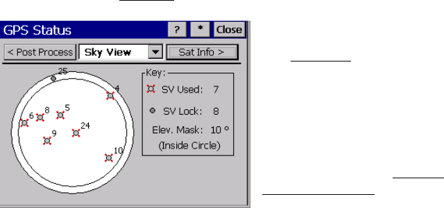
Sky View
The Sky View card displays a plot of the
satellites tracked and the elevation mask
boundary.
SV Used: / SV Lock: See the Receiver Card,
Page R-176
Ele
v Mask: Displays the elevation mask
currently set on the General card of the
Receiver Settings
screen.