
Reference Manual


Table Of Contents
- Table of Contents
- Welcome
- Main Menu
- File Menu
- Job Menu
- Job Menu – GPS
- Job Menu – Basic GPS
- Survey Menu
- Backsight Setup
- Traverse / Sideshot
- Repetition Shots
- Multiple Sideshots
- Radial Sideshots
- Distance Offset Shot
- Horizontal Angle Offset
- Vertical Angle Offset
- Auto Collect
- Corner & 2 Lines
- Corner & Angle
- Corner & Offset
- Corner & Plane
- Surface Scan
- Video Scan
- Shoot From Two Ends
- Record Mode
- Resection
- Remote Elevation
- Check Point
- Solar Observation
- Remote Control
- Survey Menu – GPS
- Survey Menu – Basic GPS
- Leveling Menu
- Stakeout Menu
- Stakeout Menu – GPS and Basic GPS
- Inverse Menu
- Cogo Menu
- Curve Menu
- Roads Menu
- Adjust Menu
- Miscelaneous Screens
- Appendix A
- Index
Survey Pro Reference Manual
R-176
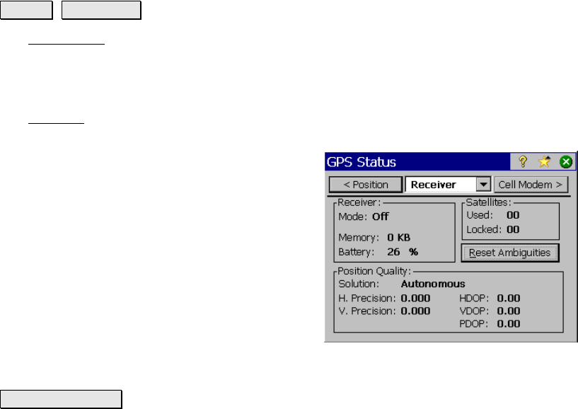
GPS Status
Survey GPS Status.
The GPS Status screen contains several index card-format screens
providing real time status of the active receiver.
Receiver
The Receiver card displays information about the receiver mode and
GPS solution quality.
Mode: displays if the receiver is set to Off,
Base, Rover, or Post Processing mode.
Memory: displays the amount of memory
remaining in the receiver’s internal storage
card.
Battery: displays the remaining battery charge
in the receiver.
Satellites: displays the number of satellites:
• Used: by the receiver for the current
GPS solution.
• Locked: (Tracked) by the receiver.
Reset Ambiguities : is used to reinitialize the receiver’s RTK engine.
Solution: displays the type and quality of solution. It will be one of
the following values:
• No Communication: we are not receiving a response to
commands.
• No Data: we are receiving an unknown or a bad response to
commands.
• No RTK Solution: we are receiving a response, but the
receiver is not computing a solution.
• Autonomous: we are receiving a stand-alone solution
(accuracy is about 100 meters).