
Reference Manual


Table Of Contents
- Table of Contents
- Welcome
- Main Menu
- File Menu
- Job Menu
- Job Menu – GPS
- Job Menu – Basic GPS
- Survey Menu
- Backsight Setup
- Traverse / Sideshot
- Repetition Shots
- Multiple Sideshots
- Radial Sideshots
- Distance Offset Shot
- Horizontal Angle Offset
- Vertical Angle Offset
- Auto Collect
- Corner & 2 Lines
- Corner & Angle
- Corner & Offset
- Corner & Plane
- Surface Scan
- Video Scan
- Shoot From Two Ends
- Record Mode
- Resection
- Remote Elevation
- Check Point
- Solar Observation
- Remote Control
- Survey Menu – GPS
- Survey Menu – Basic GPS
- Leveling Menu
- Stakeout Menu
- Stakeout Menu – GPS and Basic GPS
- Inverse Menu
- Cogo Menu
- Curve Menu
- Roads Menu
- Adjust Menu
- Miscelaneous Screens
- Appendix A
- Index
Survey Pro Reference Manual
R-172
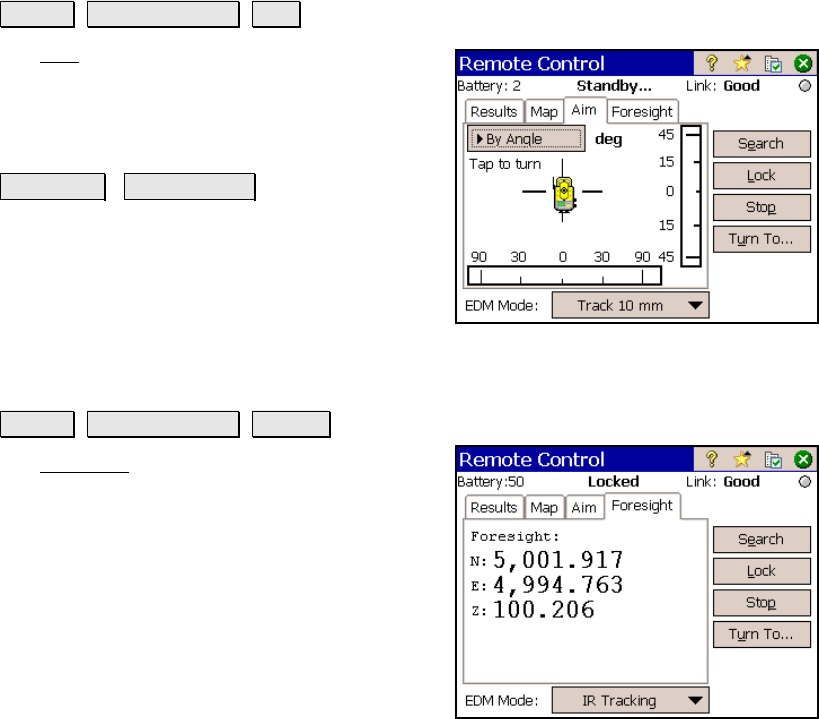
Aim Card
Survey Remote Control Aim.
The Aim card is used to precisely aim the
instrument. Tapping around the total station
graphic will turn the instrument to the location
corresponding to the horizontal and vertical
scale bars.
By Angle / By Distance : toggles between
turning by angles or by distances, respectively.
The scales in the scale bars will also switch
between angles or distances. The scales in the
scale bars are calculated using the last
distance that was measured.
Foresight Card
Survey Remote Control Results.
The Foresight card is available only if the
backsight is solved. It displays live coordinates
for the current foresight.