
Reference Manual


Table Of Contents
- Table of Contents
- Welcome
- Main Menu
- File Menu
- Job Menu
- Job Menu – GPS
- Job Menu – Basic GPS
- Survey Menu
- Backsight Setup
- Traverse / Sideshot
- Repetition Shots
- Multiple Sideshots
- Radial Sideshots
- Distance Offset Shot
- Horizontal Angle Offset
- Vertical Angle Offset
- Auto Collect
- Corner & 2 Lines
- Corner & Angle
- Corner & Offset
- Corner & Plane
- Surface Scan
- Video Scan
- Shoot From Two Ends
- Record Mode
- Resection
- Remote Elevation
- Check Point
- Solar Observation
- Remote Control
- Survey Menu – GPS
- Survey Menu – Basic GPS
- Leveling Menu
- Stakeout Menu
- Stakeout Menu – GPS and Basic GPS
- Inverse Menu
- Cogo Menu
- Curve Menu
- Roads Menu
- Adjust Menu
- Miscelaneous Screens
- Appendix A
- Index
Survey Pro Reference Manual
R-168
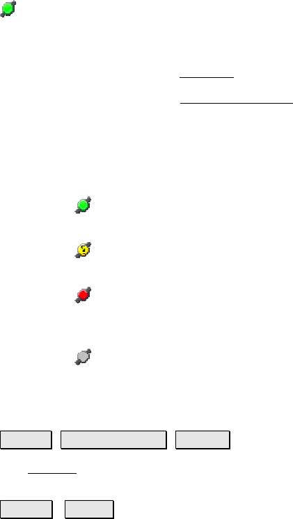
The satellite icon in the Command Bar indicates the status of the
satellite connection when using GeoLock. Tapping this icon will
display a pop-up list with the following items:
• Sky Plot: opens the Sky Plot
screen. (Page R-173)
• Settings: opens the GeoLock Settings
screen. (Page R-174)
• Reset: Resets the GPS localization solution.
• Sats: is an output-only field that will display one of the
following messages, which will change along with the color of
the satellite icon:
o
(green icon) On - Ready: GeoLock is active and a
localization solution exists.
o
(yellow icon) On - Collecting Data: GeoLock is active
but a localization solution does not yet exist.
o
(red icon) No GPS Data or GeoLock requires
Backsight set: No NMEA data is available or the
backsight has not yet been set.
o
(gray icon) Off: GeoLock is not enabled.
Results Card
Survey Remote Control Results.
The Results card displays live angle data from the total station and
live distance data is displayed depending on the current EDM mode.
HD/VD / ZA/SD : Toggles the data displayed from the total station
between HA, HD and VD, or HA, ZA and SD.