
Reference Manual


Table Of Contents
- Table of Contents
- Welcome
- Main Menu
- File Menu
- Job Menu
- Job Menu – GPS
- Job Menu – Basic GPS
- Survey Menu
- Backsight Setup
- Traverse / Sideshot
- Repetition Shots
- Multiple Sideshots
- Radial Sideshots
- Distance Offset Shot
- Horizontal Angle Offset
- Vertical Angle Offset
- Auto Collect
- Corner & 2 Lines
- Corner & Angle
- Corner & Offset
- Corner & Plane
- Surface Scan
- Video Scan
- Shoot From Two Ends
- Record Mode
- Resection
- Remote Elevation
- Check Point
- Solar Observation
- Remote Control
- Survey Menu – GPS
- Survey Menu – Basic GPS
- Leveling Menu
- Stakeout Menu
- Stakeout Menu – GPS and Basic GPS
- Inverse Menu
- Cogo Menu
- Curve Menu
- Roads Menu
- Adjust Menu
- Miscelaneous Screens
- Appendix A
- Index
Survey Pro Reference Manual
R-160
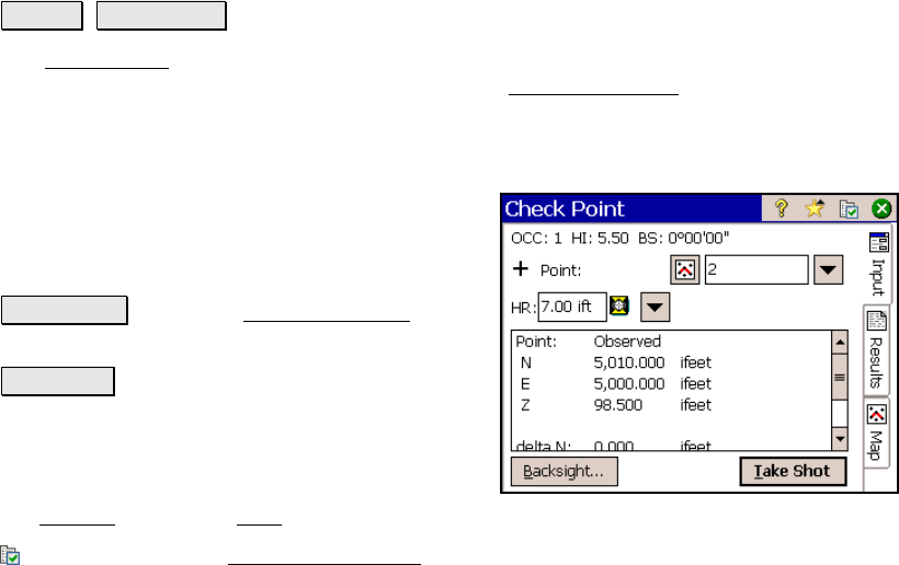
Check Point
Survey Check Point.
The Check Point screen compares the rod location with an existing
point in the project. This routine is similar to the Check Backsight
routine (Page R-126) and is used to verify that the rod and/or the
tota
l station is over the correct point. This routine does not store a
new point.
Point: is the point from the project that will be
compared to the observed point (rod location).
Height of Rod: is the length of the rod.
Backsight… : opens the Backsight Setup screen
(Page R-122).
Take Shot : takes a shot and displays the
deltas between the observed point and the
selected point. High delta values can indicate
either the rod and/or total station is over the
wrong point. The deltas can also be viewed in
the Results
screen and Map screen.
: is a shortcut to the Surveying Settings screen (Page R-44).