
Reference Manual


Table Of Contents
- Table of Contents
- Welcome
- Main Menu
- File Menu
- Job Menu
- Job Menu – GPS
- Job Menu – Basic GPS
- Survey Menu
- Backsight Setup
- Traverse / Sideshot
- Repetition Shots
- Multiple Sideshots
- Radial Sideshots
- Distance Offset Shot
- Horizontal Angle Offset
- Vertical Angle Offset
- Auto Collect
- Corner & 2 Lines
- Corner & Angle
- Corner & Offset
- Corner & Plane
- Surface Scan
- Video Scan
- Shoot From Two Ends
- Record Mode
- Resection
- Remote Elevation
- Check Point
- Solar Observation
- Remote Control
- Survey Menu – GPS
- Survey Menu – Basic GPS
- Leveling Menu
- Stakeout Menu
- Stakeout Menu – GPS and Basic GPS
- Inverse Menu
- Cogo Menu
- Curve Menu
- Roads Menu
- Adjust Menu
- Miscelaneous Screens
- Appendix A
- Index
Survey Menu – Conventional Mode
R-159
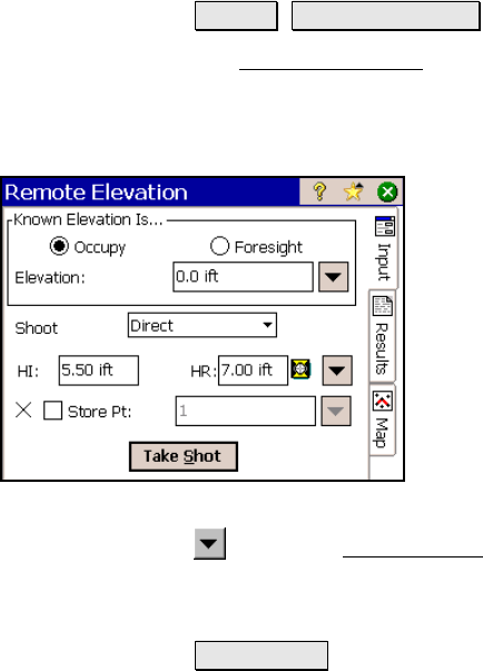
Remote Elevation
Survey Remote Elevation.
The Remote Elevation screen will compute the elevation for the
occupy point by shooting a foresight with a known elevation, or it will
compute the elevation for a foresight when the occupy elevation is
known.
Known Elevation Is…: is where you specify if
the Occupy point or the Foresight point has a
known elevation.
Elevation: is the known elevation for the
selected point.
Shoot: defines if you want to perform a Direct
shot only, or Direct & Reverse shots to the
foresight.
HI: is the distance that the total station is
above the ground.
HR: is the length of the rod.
: opens the Smart Target options (Page R-456).
; Store Pt: When checked, the elevation of the point specified here
will be replaced with the computed elevation.
Take Shot… : computes the elevation for the point that had an
unknown elevation and optionally writes that elevation to the
specified Store Pt.
Results
OCC Elevation: displays the elevation for the occupy point.
FS Elevation: displays the elevation for the foresight point.