
Reference Manual


Table Of Contents
- Table of Contents
- Welcome
- Main Menu
- File Menu
- Job Menu
- Job Menu – GPS
- Job Menu – Basic GPS
- Survey Menu
- Backsight Setup
- Traverse / Sideshot
- Repetition Shots
- Multiple Sideshots
- Radial Sideshots
- Distance Offset Shot
- Horizontal Angle Offset
- Vertical Angle Offset
- Auto Collect
- Corner & 2 Lines
- Corner & Angle
- Corner & Offset
- Corner & Plane
- Surface Scan
- Video Scan
- Shoot From Two Ends
- Record Mode
- Resection
- Remote Elevation
- Check Point
- Solar Observation
- Remote Control
- Survey Menu – GPS
- Survey Menu – Basic GPS
- Leveling Menu
- Stakeout Menu
- Stakeout Menu – GPS and Basic GPS
- Inverse Menu
- Cogo Menu
- Curve Menu
- Roads Menu
- Adjust Menu
- Miscelaneous Screens
- Appendix A
- Index
Survey Pro Reference Manual
R-158
456).
Take Shot… : Takes a shot to the prism at the specified foresight
point. After the last shot is performed, the Save Point dialog box will
open, described next.
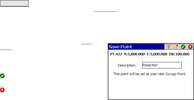
Save Point
Once the final shot is completed, the Save
Point dialog box will open showing the
computed coordinates for the occupy point.
Description: is the desired description for the
point that will be stored.
: stores the new point and automatically sets
the point as the current occupy point.
: exits the dialog without storing a new
point.
Results
Resection
OC N: is the computed northing of the Occupy Point.
OC E: is the computed easting of the Occupy Point.
OC Z: is the computed elevation of the Occupy Point.
Residuals
dRMS: is the average distance residual from all shots performed.
aRMS: is the average horizontal angle residual from all shots
performed.
FS: is the foresight name.
dHD: is the distance difference of the measured shot and the
computed shot. d(H)orizontal(D)elta
dHA: is the angle difference of the measured shot and the computed
shot. d(H)orizontal(A)ngle