
Reference Manual


Table Of Contents
- Table of Contents
- Welcome
- Main Menu
- File Menu
- Job Menu
- Job Menu – GPS
- Job Menu – Basic GPS
- Survey Menu
- Backsight Setup
- Traverse / Sideshot
- Repetition Shots
- Multiple Sideshots
- Radial Sideshots
- Distance Offset Shot
- Horizontal Angle Offset
- Vertical Angle Offset
- Auto Collect
- Corner & 2 Lines
- Corner & Angle
- Corner & Offset
- Corner & Plane
- Surface Scan
- Video Scan
- Shoot From Two Ends
- Record Mode
- Resection
- Remote Elevation
- Check Point
- Solar Observation
- Remote Control
- Survey Menu – GPS
- Survey Menu – Basic GPS
- Leveling Menu
- Stakeout Menu
- Stakeout Menu – GPS and Basic GPS
- Inverse Menu
- Cogo Menu
- Curve Menu
- Roads Menu
- Adjust Menu
- Miscelaneous Screens
- Appendix A
- Index
Survey Pro Reference Manual
R-146
Backsight : opens the Backsight Setup screen (Page R-122) where the
current backsight can be modified.
Note: After each shot is complete, the computed elevation is
displayed for the new point. You can either enter a different
elevation or tap to accept the computed elevation.
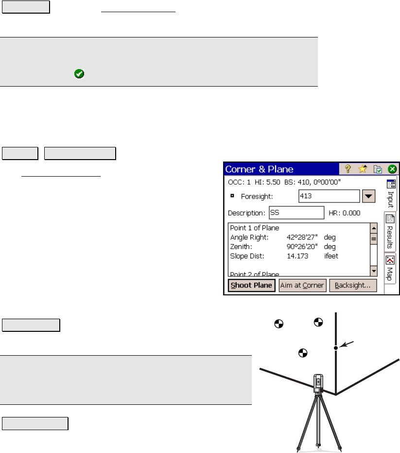
Corner & Plane
Survey Corner & Plane.
The Corner and Plane screen is used to store a
point using a reflectorless total station for a
point that cannot be shot, but three points on
the same plane can be shot.
Foresight: is the name of the point that will be
stored.
Description: is the description for the point
that will be stored.
HR: 0.000: shows that no rod height will be
used with this routine since all shots are direct
reflectorless.
Shoot Plane : will prompt you to take three shots on
the same flat surface that the new point is located.
Note: Each shot can be in any location on the same
plane, but they must not form a straight line and they
should not be grouped close together.
Aim at Corner : will prompt you to aim at the corner
(the point that you want to store). Although no shot is
taken, the angles to the point will be used to compute
its location.
Aim at target
(no shot)
Shot 1
Shot 2
Shot 3
Corner & Plane