
Reference Manual


Table Of Contents
- Table of Contents
- Welcome
- Main Menu
- File Menu
- Job Menu
- Job Menu – GPS
- Job Menu – Basic GPS
- Survey Menu
- Backsight Setup
- Traverse / Sideshot
- Repetition Shots
- Multiple Sideshots
- Radial Sideshots
- Distance Offset Shot
- Horizontal Angle Offset
- Vertical Angle Offset
- Auto Collect
- Corner & 2 Lines
- Corner & Angle
- Corner & Offset
- Corner & Plane
- Surface Scan
- Video Scan
- Shoot From Two Ends
- Record Mode
- Resection
- Remote Elevation
- Check Point
- Solar Observation
- Remote Control
- Survey Menu – GPS
- Survey Menu – Basic GPS
- Leveling Menu
- Stakeout Menu
- Stakeout Menu – GPS and Basic GPS
- Inverse Menu
- Cogo Menu
- Curve Menu
- Roads Menu
- Adjust Menu
- Miscelaneous Screens
- Appendix A
- Index
Survey Menu – Conventional Mode
R-143
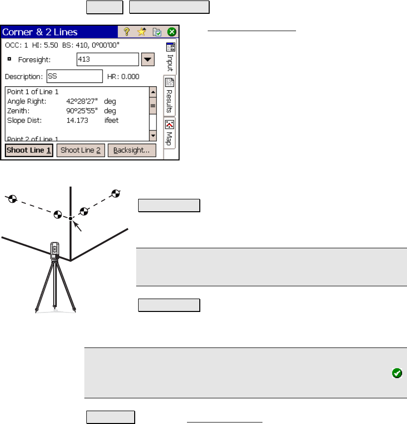
Corner & 2 Lines
Survey Corner & 2 Lines.
The Corner and 2 Lines screen is used to store
a point at the corner of a structure using a
reflectorless total station where a direct
measurement to the point is not possible, but
two points on two intersecting lines can be
shot.
Foresight: is the name of the point that will be
stored.
Description: is the description for the point
that will be stored.
HR: 0.000: shows that no rod height will be
used with this routine since all shots are direct
reflectorless.
Shoot Line 1 : will prompt you to take two shots on Line
1, which intersects with Line 2 at the point you want to
store.
Note: Each shot for a line can be in any location on the
same line. (Shot 1 can be to the left or the right of Shot 2.)
Shoot Line 2 : will prompt you to take two shots on Line
2, which intersects with Line 1 at the point you want to
store.
Note: After all shots are done, the computed elevation is displayed
for the new point. You can either enter a different elevation or tap
to accept the computed elevation.
Backsight : opens the Backsight Setup screen (Page R-122) where the
current backsight can be modified.
Line 1
Line 2
Target
1
1
2
2
Corner & 2 Lines