
Reference Manual


Table Of Contents
- Table of Contents
- Welcome
- Main Menu
- File Menu
- Job Menu
- Job Menu – GPS
- Job Menu – Basic GPS
- Survey Menu
- Backsight Setup
- Traverse / Sideshot
- Repetition Shots
- Multiple Sideshots
- Radial Sideshots
- Distance Offset Shot
- Horizontal Angle Offset
- Vertical Angle Offset
- Auto Collect
- Corner & 2 Lines
- Corner & Angle
- Corner & Offset
- Corner & Plane
- Surface Scan
- Video Scan
- Shoot From Two Ends
- Record Mode
- Resection
- Remote Elevation
- Check Point
- Solar Observation
- Remote Control
- Survey Menu – GPS
- Survey Menu – Basic GPS
- Leveling Menu
- Stakeout Menu
- Stakeout Menu – GPS and Basic GPS
- Inverse Menu
- Cogo Menu
- Curve Menu
- Roads Menu
- Adjust Menu
- Miscelaneous Screens
- Appendix A
- Index
Survey Pro Reference Manual
R-140
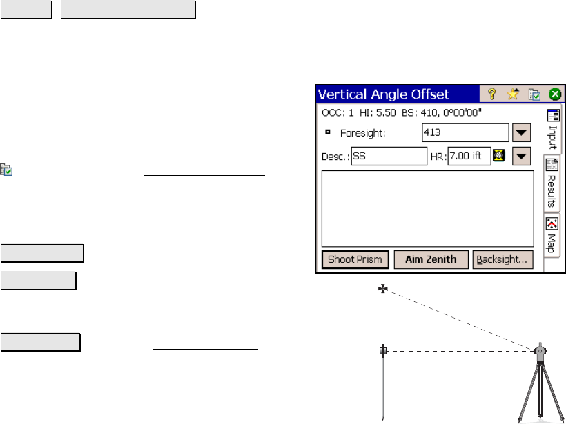
Vertical Angle Offset
Survey Vertical Angle Offset.
The Vertical Angle Offset screen allows you to compute and store the
location of a new point that exists directly above or below the rod
location, but cannot be occupied, such as the
top of a utility pole.
The new point will have the same coordinates
as the rod location, but with a different
elevation.
: is a shortcut to the Surveying Settings
screen (Page R-44).
Foresight: is the
point name that will be used
when storing the new point.
Shoot Prism : will take a shot to the prism.
Aim Zenith : will read the vertical angle
measured by the total station, which should be facing the
new point’s location.
Backsight… : opens the Backsight Setup screen (Page R-
122).