
Reference Manual Owner manual


Survey Pro Reference Manual
R-60
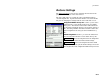
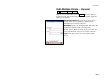
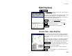
Edit Point – Geodetic
Job Edit Points Edit… Geodetic.
The Geodetic card applies primarily to Survey Pro with GPS users.
Refer to the GPS Reference Manual for more information on this
card.
; Has Geodetic Data: when checked, this allows you to
edit the geodetic coordinates for a point.
Advanced… : will open the Edit GPS Point Flags screen
to select the advanced settings for the selected point.
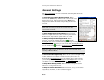
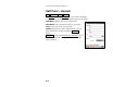
Edit GPS Point Flags Screen
Survey Control Points Edit Point Set Flags.
The Edit GPS Point Flags screen is used to select the
advanced settings for the selected point.
Set Up Group: is the set up group of the point. (See the
User’s Manual for more information on set up groups.)
GPS Control Point: When checked, will include the selected point in
the list of localization control points.
Use for Horizontal Localization: When checked, will use the point
for horizontal control in the localization solution.
Use for Vertical Localization: When checked, will use the point for
vertical control in the localization solution.
Use as localization calculator grid origin: When checked, identifies
the selected point as the local grid origin for computing rotation in
localization calculator solutions. (See the GPS User’s Manual for
more information on localization calculator.).
Accept : accepts the screen selections and returns to the previous
screen.