
Reference Manual Owner manual

Survey Pro Reference Manual
R-410
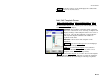
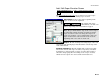
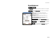
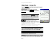
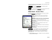
Stake Road – Screen Two
The second Stake Road screen displays a cross-sectional profile view
of the road at the current station. Any particular point on this view
can be selected and staked.
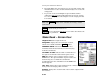
Station Interval: is the value that is added to the
Station to Stake after the Next Station button is pressed.
Next Station : advances the Station to Stake by the
Station Interval.
Note: If the Stake Corners option is selected in the
Stakeout Settings screen, the Next Station button will
also stop at any horizontal or vertical alignment node,
and the beginning and end of any widening and super
elevation that falls within the interval.
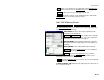
<< , >> : These buttons are used to select the
particular node, or an offset to it, from your road profile
that you wish to stake. The segment name at the selected node is
also displayed. If staking the centerline with an offset, the side of the
road that the offset occurs is also displayed.
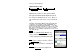
Offset: When checked, allows you to specify an offset distance to
stake as opposed to staking the actual node locations.
Note: A positive value offset is applied at the specified distance from
each node away from the centerline. A negative value offset is
applied at the specified distance from each node toward the
centerline.
Note: If an offset occurs past the edge of the road, no vertical or cut /
fill information will be computed for that point.
Subgrade: When checked, allows you to specify a vertical offset from
the actual node locations. Positive values result in the stake location