
Reference Manual Owner manual
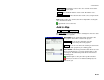

Survey Pro Reference Manual
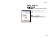
R-366
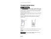
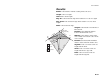
HD/VD to SD/ZA
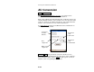
Cogo HD/VD to SD/ZA.
The HD/VD to SD/ZA screen will convert a vertical and horizontal
distance to an equivalent slope distance and zenith angle.
Horz Dist: is the horizontal distance from the occupy
point to the foresight point.
Vert Dist: is the vertical distance from the occupy point
to the foresight point.
HI: is the distance that the total station is above the
ground.
HR: is the length of the rod.
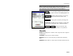
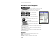
: opens the Smart Target options (Page R-444).
; Earth Curvature Adjust: When checked, the resulting
zenith angle and slope distance will account for the
curvature of the earth and refraction.
Solve : computes the equivalent slope distance and
zenith angle from the data entered.
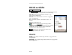
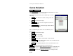
Results
Zenith: is the computed zenith angle from the occupy point to the
foresight point.
Slope Dist: is the computed slope distance from the occupy point to
the foresight point.