
Reference Manual Owner manual

COGO Menu
R-361
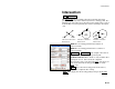
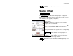
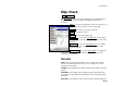
Map Check
Cogo Map Check.
The Map Check screen is used to manually enter boundaries from a
map to check for closure and other information related to the
boundary.
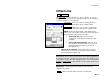
Edit… : accesses the appropriate editor screen where you
can edit the selected line or curve from the list.
Delete : deletes the selected line segment.
Clear : clears all line entries.
Closure : accesses the Results page.
Add Line… : accesses the Add / Edit Line screen, (Page
R-362), where a new line can be added prior to the select
segment.
Add Arc… : accesses the Add / Edit Curve screen (Page
R-362) where a new curve can be added prior to the
selected segment.
Add to Map… : accesses the Add to Map screen (Page R-
363) where the map data entered in the list can be added to the
current job as a polyline.
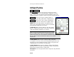
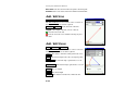
Results
Area: is the area that the boundary encloses. If the start and end
points are in different locations, the area is computed as if a line
joined these two points.
Length: is the length of the boundary from the first point to the last
point.
Perimeter: is the length of the boundary from the first point to the
last point, plus any additional length between the last point and the
first point.
Error dist.: is the distance between the last point and the first point.