
Reference Manual Owner manual


Survey Pro Reference Manual
R-346
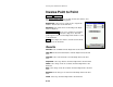
North: is the Y-coordinate on the specified line, tangent to the
perpendicular offset.
East: is the X-coordinate on the specified line, tangent to the
perpendicular offset.
Elevation: is the elevation on the specified line, tangent to the
perpendicular offset.
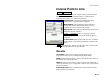
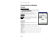
Inverse Point to Polyline
Inverse Point to Polyline.
The Inverse Point to Polyline screen computes the offset distance
from a known point perpendicular to a polyline.
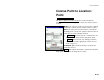
Inverse Point: is the known point that the offset to a
polyline segment is computed.
Begin Station: is the starting station assigned to the
beginning of the polyline, which is used to compute the
Station in the results.
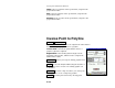
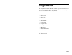
Tap Polyline : allows you to tap an existing polyline from
a map view.
Editor : accesses the Polyline Editor (Page R-62) where a
new polyline can be created or an existing polyline can
be modified.
Tap Points : provides a map view where you can tap any
existing points to create a temporary polyline.
To/From : provides point selection by entering point
names.