
Reference Manual Owner manual


Survey Pro Reference Manual
R-344
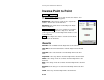
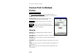
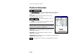
Inverse Point to Point
Inverse Point to Point.
The Inverse Point to Point screen will calculate the distance and
direction between two existing points.
Begin Point: is the reference point used to compute the
distance and direction to the End Point.
End Point: is the point whose relationship to the Begin
Point is computed.
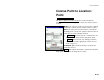
Select from Map… : allows you to quickly select both the
Begin Point and End Point from a map view. The first
point tapped is entered as the Begin Point and the second
as the End Point.
Solve : will compute the distance and direction from the
Begin Point to the End Point.
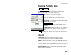
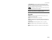
Results
Azimuth: is the azimuth from the Begin Point to the End Point.
Horz Dist: is the horizontal distance from the Begin Point to the End
Point.
Vert Dist: is the vertical distance from the Begin Point to the End
Point.
Slope Dist: is the slope distance from the Begin Point to the End Point.
North: is the change in the Y-coordinate from the Begin Point to the
End Point.
East: is the change in the X-coordinate from the Begin Point to the End
Point.
Elevation: is the change in elevation from the Begin Point to the End
Point.
Grade: is the slope from the Begin Point to the End Point.