
Reference Manual Owner manual


Stakeout Menu – GPS & Basic GPS Module
R-337
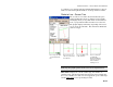
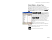
Obs. Slope: is the computed (observed) cut or fill slope based on the
last shot and the corresponding hinge point.
Des. Slope: is the design cut or fill slope.
Cut / Fill: is the cut or fill required for the current rover location to be
positioned on the design slope.
Toward CL / Away CL: is the computed horizontal distance that the
rod must move either toward the centerline or away from it,
respectively, before it is positioned at the catch point.
Note: The computed horizontal distance is based on the observed
terrain computed from the last two shots. If only one shot has been
taken, it is assumed that the terrain is level when computing this
value.
On Station / Back Sta / Ahead Sta: informs you if the rod is on the
station being staked, or the distance it must move (parallel to the
centerline) back or ahead to be on the correct station.
HD to HP: is the horizontal distance from the rod to the hinge point.
VD to HP: is the vertical distance from the rod to the hinge point.
HD to CL: is the horizontal distance from the rod to the centerline.
VD to CL: is the vertical distance from the rod to the centerline.
Line and Offset
Stakeout Line and Offset.
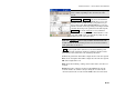
The instructions for the Line and Offset routine for GPS similar to
the conventional method, except that the Backsight and Circle Zero
buttons are replaced with a Setup HR button to configure rover
antenna and the backsight information is replaced with rover
antenna height information. See Page R-299 for details.