
Reference Manual Owner manual


Survey Pro Reference Manual
R-336
precision computed by the receiver. Tap on this button to open the
detailed GPS Status screen
(Page R-168).
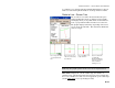
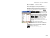
The first button selects the type of slope that will be used between the
catch point and hinge point from the following options:
• Automatic Slope : selects the slope based on the current
rover position. If the rover is above the hinge point, a cut
slope is computed. If the rover is below the hinge point, a fill
slope is computed.
• Force CUT Slope : forces all computations to be based on a
cut slope.
• Force FILL Slope : forces all computations to be based on a
fill slope.
The second button selects which information is displayed in the lower
corner of the screen from the following options:
• V. Map : displays a cross-sectional view at the current
station.
Note: When you tap a map view, an expanded view of the same map
will fill the screen.
Note: The Vertical Map will show an X at the location of each
previous shot. This can be useful in determining if the current
terrain will never intersect the slope (no catch point).
• H. Map : displays an overhead view of the job.
• N,E,Z : displays the coordinates computed from the last
shot.
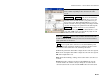
Occupy…: switches the receiver dynamics to static (depending on
settings) and opens the Occupy Data Points screen (Page R-191)
where data can be collected for the current point.
Topo SS : allows you to store a side shot measurement during stake
out. This button opens a prompt for the side shot point name and
opens the GPS Occupy Data Points
screen. After you store the new
point (or cancel) you will resume with the Slope Staking
screen.
Results: displays the results computed from the last Shot.