
Reference Manual Owner manual


Stakeout Menu – GPS & Basic GPS Module
R-335
Slope Staking
Stakeout Slope Staking.
The Slope Staking screen is used to locate the catch points for a
roadway in any terrain.
The first screens of this routine are similar to the conventional
method except that the Backsight and Circle Zero buttons are replaced
with a Setup HR button to configure rover antenna and the backsight
information is replaced with rover antenna height information. See
Page R-288 for details.
Once the centerline of the road is selected and the road profile is
defined, the fourth Slope Staking
screen is used to locate the stake
point at the current station.
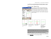
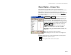
Slope Staking – Screen Four
The graphic portion of the Horizontal Map and Vertical Map is updated
continuously. This allows the user at the rover position to watch the
movement of the rover in relation to the slope and easily position the
rod over the catch point.
Note: You can tap in the graphic portion of the screen to
open the graphic in a larger window.
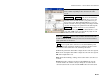
Although the graphic portion of the screen is
continuously updated, the numeric values are not
updated until the Shot button is tapped. The correct
procedure for slope staking in GPS mode is to use the
graphic portion of the screen to locate the catch point as
closely as possible and press Shot. Once the position is
satisfactory, you can determine if the rover needs to be
moved again.
GPS Status: displays the current solution type, the
number of satellites used, and the horizontal and vertical