
Reference Manual Owner manual


Survey Pro Reference Manual
R-330
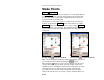
Stake Points
Stakeout Stake Points.
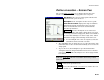
The GPS Staking screen is used to navigate to a design point with the
receiver in roving mode. Once the design point has been staked, this
screen is also used to control static occupations for the most precise
measurement to the as built point.
The first two screens of this routine are similar to the conventional
method, except that the Backsight button on the first screen and the
Circle Zero button on the second screen are replaced with a Setup HR
button to configure rover antenna. The backsight information is
replaced with rover antenna height information. See Page R-270 for
comparison.
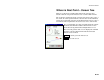
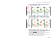
Roving using
navigation method Roving using navigation method
There are two navigation methods available when staking a point and
you can switch between them by tapping the
/
button.
When using the
method, a large red arrow indicates the direction
of travel and always appears at the top of the graphic. This arrow
will dim when at a standstill or when near the design point. A north
and south indicator are displayed on the graphic and will rotate
depending on your direction of travel along with a blue line that
indicates the direction to your reference point or azimuth. When you