
Reference Manual Owner manual

File Menu
R-25
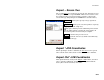
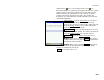
Export *.TXT Coordinates – Screen
Two
Select the desired order and format for the resulting TXT
file from the list of options.
Finish : exports the selected points to the TXT file.
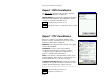
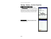
Export *.CSV Coordinates
This routine is identical to the Export *.TXT Coordinates
routine, described above with the exception that the
formatting for the exported file is automatically set to
comma delimited and the extension for the file name will
be *.CSV.
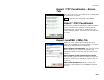
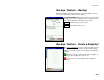
Export LandXML (.XML) File
Unlike the other export routines, which only export
points, the LandXML export routine allows you to export
points along with polylines and alignments.
Export polylines and alignments: will export the points
in the current project as well as any polylines and
alignments. If this is unchecked, only the points will be
exported.
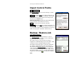
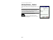
Export polylines on the specified layer as parcels:
will export the polylines on the selected layer as parcels.
(Polylines on other layers will still be exported, only not
as parcels.)
Export point description as: allows you to select to
export the point descriptions as LandXML descriptions
or codes.