
Reference Manual Owner manual


Survey Pro Reference Manual
R-318
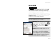
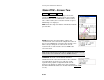
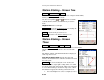
Stake DTM – Screen Two
Stakeout Stake DTM Next >.
The second Stake DTM screen displays all relevant
information for the current rod position and a graphic
that shows the reference DTM surface and its corners.
Once a shot is taken, the rod location and the occupied
TIN triangle are displayed.
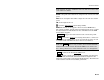
Data: shows the angle and distance information from the
previous shot.
Result: shows the current northing, easting, and
elevation of the rod as well as the computed elevation of
the reference DTM at the current location and the cut or
fill necessary to bring the elevation at the current
location to the elevation of the reference DTM at the
current location.
Note: If the DTM and Cut or Fill fields are blank after taking a shot, it
indicates the rod is outside the reference DTM boundary.
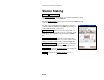
Centerline: shows the current station and offset
information for the rod location relative to the centerline
selected from the previous screen. The type of line
segment in the polyline or alignment at the current
station is also displayed. (This card is only available if
the With Centerline checkbox was checked in the first Stake DTM
screen.)