
Reference Manual Owner manual

Survey Pro Reference Manual
R-290
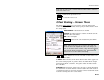
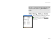
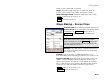
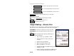
Slope Staking – Screen Four
The fourth screen is used to perform the actual slope staking shots.
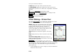
Left / Right: displays if a Cut or Fill slope is being
computed and if it is on the Left or Right side of the road,
respectively.
Rod Elev: is the current elevation at the rod location.
Des. Slope: is the design cut or fill slope.
Obs. Slope: is the computed (observed) cut or fill slope
based on the last shot and the corresponding hinge point.
Cut / Fill: is the cut or fill required for the current rod
location to be positioned on the design slope.
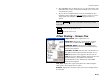
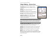
Toward CL / Away CL: is the computed horizontal
distance that the rod must move either toward the
centerline or away from it, respectively, before it is
positioned at the catch point.
Note: The computed horizontal distance is based on the observed
terrain computed from the last two shots. If only one shot has been
taken, it is assumed that the terrain is level when computing this
value.
On Station / Back Sta / Ahead Sta: informs you if the rod is on the
station being staked, or the distance it must move (parallel to the
centerline) back or ahead to be on the correct station.
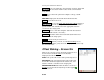
HD to HP: is the horizontal distance from the rod to the hinge point.
VD to HP: is the vertical distance from the rod to the hinge point.
HD to CL: is the horizontal distance from the rod to the centerline.
VD to CL: is the vertical distance from the rod to the centerline.
EDM: This button can be toggled to shoot in various EDM modes.
The options available depend on the total station being used. Consult
the total station’s documentation for more information on the EDM
modes that it supports.