
Reference Manual Owner manual


Survey Menu – GPS Module
R-233
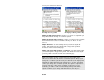
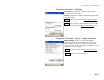
• Database Zone: will display controls to pick a map projection
from the zone groups and zones in the database.
• Database Site: will display controls to pick a localized site record
from either the Site zone group or the TDS Localization
ZoneGroup group.
• Current Projection: will disable the edit boxes and display the
current projection details. The job file coordinate system record
will be used
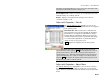
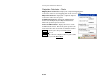
Adjust with Projection – Select Destination
Coordinate System
The Adjust with Projection Select Destination Coordinate System
screen is used to select the coordinate system to transform the job file
points into. The interface is identical to the Select Source Coordinate
System screen described above. This screen only shows when the
adjustment mode is set to Adjust From Source to Destination.
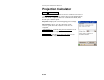
Adjust with Projection – Prompt Adjust
The Adjust with Projection Prompt Adjust screen is used to describe
the difference between the source and destination record, and to
prompt you whether or not you wish to adjust the job with the change
of projection. This screen only shows when the wizard is opened
because of a change of projection record.