
Reference Manual Owner manual

Survey Menu – GPS Module
R-227
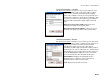
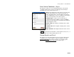
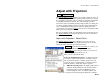
Enter Control Coordinate – Key In
The purpose of this screen is to manually input the control point
coordinates. This is the second screen that appears when Key In
Coordinate was selected in the first screen.
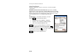
Point (n / x): displays the name of the selected job point
that the control point source will be merged into. A
counter is included where n is the number of points set
so far, including the one you are working on, and x is the
number of total points to set in this sequence.
Coordinate Type: is where you select the type of
coordinates being entered (Grid, Local LLH, or WGS84
LLH). The selection made here determines the format for
the following three fields.
Latitude / North: The Latitude / Northing of the control
point source.
Longitude / East: The Longitude / Easting of the control
point source.
Height / Elevation: The Height / Elevation of the control
point source.
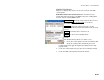
Next > : Restarts the wizard if more control points need to be set, or
opens the final screen if all control points are set.
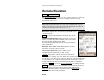
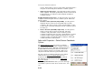
Review Results and Finish
The final screen of the wizard shows a preview of the control point
coordinates to be created. If there is only one point selected, the
Single Point Results
page will open. If there are multiple points
selected, the Multiple Points Results
page will be open.