
Reference Manual Owner manual

Survey Menu – GPS Module
R-225
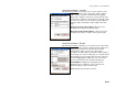
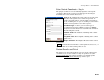
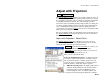
Occupy Benchmark : opens the Occupy Control Point screen (Page R-
194) where the measurement is taken by the rover on the remote
benchmark. The New Elevation field of the Remote Elevation
screen
will then display the calculated elevation for the base point to be set
on tapping Accept.
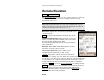
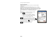
Import GPS Control
Survey Import GPS Control.
The Import GPS Control wizard is used to merge an accurate NEE
location (control point source) with a GPS collected point in the job
file. This point will then be designated as a GPS control point and can
be used to solve a localization adjustment. Solving the localization
adjustment can be done automatically at the end of this wizard,
manually after the end of this wizard, or at a later time. There are
three methods to import the control point source:
• Import from a text format ‘OPUS Solution Report’ email
• Import from a text format ‘NGS Datasheet’ file
• Key in a coordinate in NEE, LLH WGS84, or LLH local
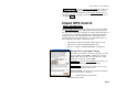
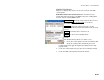
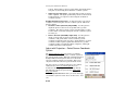
Select Points and Import Source
The first screen is used to select the job points you want
to merge with accurate NEE coordinates to convert to
GPS control and select how you will enter the control
point source to get the accurate NEE.
To/From… : opens the Select Point(s) screen where you
can select points by specifying a point range.
Tap Points… : opens a map view where you can select
points by tapping them on the screen.
Select a method…: Is used to select from the following
sources for accurate coordinates.
• OPUS Solution Results .txt file
• NGS Data Sheet .txt file