
Reference Manual Owner manual

Survey Pro Reference Manual
R-224
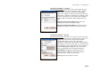
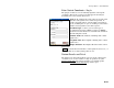
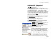
Remote Elevation
Survey Remote Elevation.
The Remote Elevation screen is used to compute and store a new base
point elevation and vertical site by occupying a known vertical
benchmark at the rover.
Note: The Remote Elevation screen is only available when a geoid
model is used for the vertical projection, the horizontal projection is
already solved and the base and rover are set.
Base Point: displays the current base point number and
elevation details.
Info : opens detailed information about the base point.
Add Benchmark Elevation: When checked, a new point
will be created in the job file with the entered elevation.
We will calculate (N,E) from the GPS
measurement(lat,lng) and store the new point with the
entered Elevation.
Elevation: When Add Benchmark Elevation is checked,
this is the elevation of the new point.
Select Point / New Point: is the existing or new
benchmark point name that you will occupy.
Set HR : displays the current antenna measurement
and measure to setting. You can change the antenna measurement
by entering a new value in the edit box. This new antenna height will
be sent to the receiver with your next data collection point. You can
change both the antenna measurement and measure to setting by
tapping on Set HR to open the Receiver Antenna
screen (Page R-181).
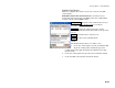
Accept : Updates the projection with the vertical solution calculated
from the control point observation and opens the Adjust with
Projection wizard to update all job file points, including the base
point, with the latest vertical solution.