
Reference Manual Owner manual

Survey Pro Reference Manual
R-222
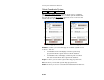
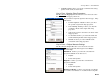
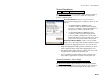
Project Location: is where you enter the local point from
which the ground coordinate scale factor is to be applied.
Coordinate Type: is where you select the type of
coordinates to enter. You can use WGS84 geodetic, local
geodetic, or grid coordinates. This choice will affect the
fields displayed below.
North/Latitude: is where you enter the northing /
latitude of the local origin.
East/Longitude: is where you enter the easting /
longitude of the local origin.
Elevation/Height: is where you enter the vertical
coordinate of the local origin.
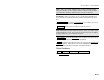
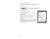
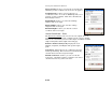
Ground Coordinates - Scale
The Ground Coordinates Scale screen is used to compute the scale
factor to convert grid to ground coordinates for the reference height.
This screen is used when you select either Key in coordinates to define
origin or Pick point to define origin on the first page.
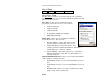
Reference Point Location (Local): displays the local
Latitude, Longitude, and Height of the ground origin
point.
Scale Factor: displays the inverse combined scale factor
for this ground setup. This scale factor is automatically
calculated based on the local ground origin.
Override scale factor: is where you can over ride the
scale factor. Check this control to enable the scale factor
edit field and enter any other scale factor.