
Reference Manual Owner manual

Survey Menu – GPS Module
R-221
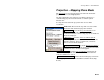
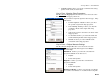
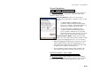
Ground Coordinates
Survey Projection Mapping Plane Ground….
The Ground Coordinates screen is used to toggle between grid and
ground coordinates, and to select how to define the origin of the
ground coordinate system.
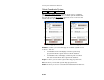
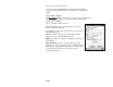
Projection Definition: is where you choose how to
represent the mapping plane coordinates. There are two
options:
• Use Grid Coordinates: WGS84 geodetic
coordinates will be transformed into mapping
plane zone coordinates. Horizontal distances on
the ground are usually scaled to the grid.
• Use Ground Coordinates: WGS84 geodetic
coordinates will be transformed into ground
scaled coordinates translated to a local origin.
Horizontal distances on the ground are 1:1 on the
grid, because the grid is scaled to the ground.
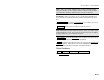
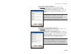
Ground Coordinates Origin: is where you select what
point to use as the origin of the ground coordinate system
relative to the origin of the mapping plane zone. You can choose to.
• Origin at mapping plane origin: ground coordinate scale factor
will be applied from the origin of the mapping plane zone.
• Pick point to define origin: ground coordinate scale factor will
be applied from a point selected from the job.
• Key in coordinates to define origin: ground coordinate scale
factor will be applied from a location entered by the user.
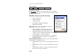
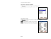
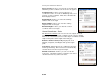
Ground Coordinates - Key In Origin
Survey Projection Mapping Plane Ground… Next >.
The Ground Coordinates Key In Origin screen is used to input the
location of the ground coordinates origin. This screen is used when
you select Key in coordinates to define origin on the Setup screen.