
Reference Manual Owner manual

Survey Menu – GPS Module
R-215
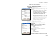
Note: Some zones in the database may not have a default datum
attached. In this case, the datum control is a list box and you must
select from the data base datums before you can set the zone.
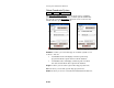
Use Geoid: is where you choose to use a geoid model with this zone.
You can pick a geoid model from the database using the drop down
box.
Select Database : opens the Select Database screen where you select
the coordinate system database to use.
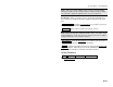
Delete Zone : Deletes the currently selected site or zone.
Note: This delete function cannot be undone. Also, you cannot delete
system database records. If you select a protected record, you will be
prompted that the record cannot be deleted.
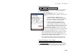
Key In Zone > opens the Key In Zone screen where you can create a
custom map projection zone, ellipsoid and datum.
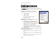
Finish accepts the currently selected zone and opens the Adjust with
Projection wizard. After the preview of the adjustment results, the
new coordinate system is set and the raw data is written.
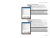
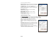
Select Database
Survey Projection Select Zone… Select Database….
The Select Database screen is described on Page R-205.