
Reference Manual Owner manual

Survey Pro Reference Manual
R-214
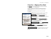
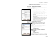
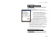
Select Coordinate System
Survey Projection Select Zone….
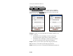
The Select Coordinate System screen is used to choose a mapping
plane zone or localized site from the coordinate system database file.
You can also open the Key In Zone
wizard to create a new zone and
datum with user specified parameters.
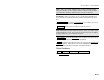
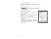
Select Mapping Plane Zone Select Mapping Plane Site
Database: is where you select what type of coordinate system record
to choose. You can:
• Use Database Zone: will display controls to pick a map
projection from the regions and zones in the database.
• Use Database Site: will display controls to pick a localized
zone based site from the Site region in the database.
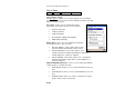
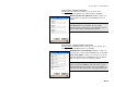
Region: is where you select the region of the map projection zone.
Zone: is where you select the specific map projection zone.
Datum: is where you view or select the horizontal datum for this zone.