
Reference Manual Owner manual

Survey Menu – GPS Module
R-213
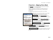
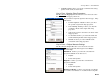
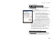
Projection – Mapping Plane Mode
The Projection screen is described below for when the horizontal
projection mode is set to Mapping Plane.
Use this setting when you want your coordinate system to be a
conformal map projection chosen from the coordinate system
database file.
See Page R-202 for when the projection mode is set to TDS
Localization.
Status Line: The text at the top of the screen describes
the status of the horizontal projection solution.
Show Details… : opens the Projection Details screen
(Page R-203), where the complete details of the
localization solution, reference map projection, and Geoid
model are displayed.
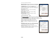
Select Zone… : opens the Select Coordinate System
screen (Page R-204), where you can choose a zone or site
from the data base, key in a custom zone, and delete
zones or sites from the database.
Mapping Plane Ground… : opens the Ground Coordinates
screen (Page R-221), where the grid to ground conversion
parameters can be calculated and applied.
Solve Localization… : opens the Solve Localization wizard (Page R-
205), where control points can be selected and the horizontal and
vertical localization are solved.
Switch to TDS Localization… : switches the horizontal projection mode
from Mapping Plane mode to Ground TDS Localization mode (Page
R-202).