
Reference Manual Owner manual


Survey Menu – GPS Module
R-211
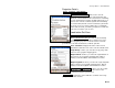
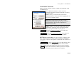
Horizontal Card
The Horizontal card shows results of the horizontal localization
solution.
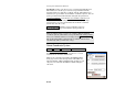
Status: displays the status of the current horizontal solution. This
will be one of the following:
• Control points solution: is displayed when the
parameters were calculated from the selected
control points.
• Current horizontal site: is displayed when there is
a horizontal solution and Solve H was not
selected on this pass.
• No horizontal solution is displayed when there is
no horizontal solution in Ground- TDS
Localization mode. This happens when you tap
Solve H, and no control points are selected.
• Unadjusted Mapping Plane: is displayed in
Mapping Plane mode when there is a mapping
plane zone selected, but no horizontal adjustment
is solved.
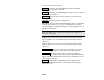
Scale: displays the scale factor.
Rotation: displays the rotation.
Delta N / E: displays the horizontal shift from the centroid of the
control points on the intermediate map projection to the centroid of
the control points in the local coordinate system.
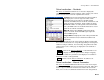
Origin N / E: displays the coordinate origin of the localization control
points. This is the centroid of the control points on the intermediate
map projection.