
Reference Manual Owner manual


Survey Pro Reference Manual
R-208
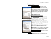
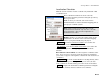
Horizontal Card
The Horizontal card is used to manually enter the six
parameters of the horizontal localization solution.
Scale: is where you enter the scale factor.
Rotation: is where you enter the rotation angle.
Translation (N,E): is where you enter the horizontal shift
(N,E) from the intermediate map projection to the local
coordinate system.
Origin (N,E): is where you enter the horizontal
coordinate (N,E) of the localization control points.
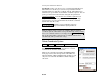
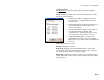
Vertical Card
The Vertical card is used to manually enter the five
parameters of the vertical localization solution.
Slope N: is where you enter the slope of the inclined
plane along the local north grid axis in parts per million.
Slope E: is where you enter the slope of the inclined
plane along the local east grid axis in parts per million.
Separation: is where you enter the separation between
the inclined plane and the local elevation.
Origin N / E: is where you enter the local origin
(north,east) of the inclined plane.
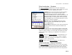
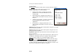
Solve > : updates the localization solution using the
values entered on the Horizontal and/or Vertical cards.