
Reference Manual Owner manual


Survey Menu – GPS Module
R-205
Select Database
Survey Projection Reset Origin… Pick from Database.
Select Database….
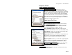
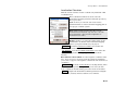
The Select Database screen is used to select the
coordinate system database to use. This screen will list
all of the coordinate system database files (*.csd) you
have in the Survey Pro directory. Highlight the .csd file
you wish to use and tap
to load the selected coordinate
system database file.
Solve Localization
Survey Projection Solve Localization….
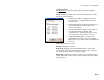
The Solve Localization wizard is used to solve a
horizontal and vertical adjustment for a coordinate
system. The user interface and procedure to solve a
localization in Ground – TDS Localization mode and
Mapping Plane mode are very similar. This section
explains how to solve a horizontal and vertical
adjustment in either projection mode.
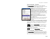
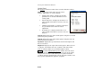
Solve Localization – Control Points
The Solve Localization Control Points screen is used to
pick control points for a least squares localization
solution, or to key in parameters for a manual
localization solution.
A list of all occupied control points matching the current
base set up group is displayed. If a point is to be used in
the horizontal and/or vertical transformation solution, a
Yes will appear in the H and/or V column for that point.
If it is not to be used in the solution, that field will be
blank.
Each point can be selected for horizontal or vertical control by
tapping the corresponding column or pressing the [H], or [V] key on
the keypad. You can double tap on a point to display information
about that point.